Smart's Brook, New Hampshire
Actually there's no place, as such, named Smart's Brook, other than in a nominal sense, as the name is attached to a mountain "brook" in the Waterville Valley. We're long familiar with Smart's Brook, having hiked there aeons ago, when our children were young and still with us on a daily basis. Now that really is a long time ago. Of such memories are lives fashioned.
Last month we re-visited the Smart's Brook trails. We'd been kind of shut out for the last few years because of work ongoing in there, around the trails. I say 'work' but we also imagine that it had more than a little to do with logging, and that's really a shame. That is, that logging is permitted in such semi-wilderness areas, where the recreational hiking public is wont to go. After all, tourists, hikers are encouraged to explore the White Mountain area of New Hampshire; it's a terrific draw for those who love the out-of-doors, brings in a lot of tourist dollars to a state which depends upon tourism.
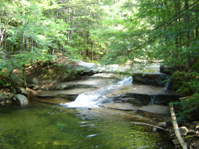
When we had explored Smart's Brook back when our children were young, we would make our away along the trail on the right-hand side to the stream to a point where the stream itself and the large flat rocks sitting within it could be accessed when the water was at a sufficiently low ebb in mid-summer. There we would sit, my husband with his sketch pad, our older boy doing the same, our younger boy scrambling up further on the rocks so he could look down on us, our daughter seated beside me feet dangling in the cold, clear water, as we admired the incomparable view, listened to the water, watched it coursing downstream. And, to our everlasting surprise, watching muscular little trout wriggling and flapping their way upstream, through the rushing water, up over the rocks, an incredible sight.
This is a great venue for people who treasure the sight of beauty to be discovered in the water falling over pancake-shaped rock formations, trees lining the banks of this mountain stream their trunks decorated with moss and lichens, as are the rocks. Going up the left-hand side of the stream the trail follows the water, and as the trail rises, the sound of the water gurgling over the rocks increases, as does the rock formation; which becomes of cliff-like proportions overlooking the stream, with lichens resembling oak leafs interleafed over one another on the sides of steep-sided rockfaces.
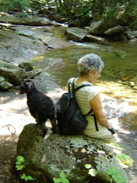
Within the first few minutes of the gentle climb the trail forks, diverting to the left - or the right, which of course follows the brook. It is also at these points where the water is most easily accessible on this side of the brook, and it is where our two little dogs, Button and Riley, get their feet happily wet with the coolness of the rushing waters and lap it thirstily, given the heat of the day. I'd love to be able to carry some of those beautiful rocks off to our home for placement in our gardens, sigh.
As the trail rises the brook falls away below, deeper and deeper into the ravine formed by the ever-rising rockface on either side of it. Huge boulders sit majestically by the steep sides, laden with lichen, haughtily permitting themselves to be photographed alongside us, the dogs. As we continue to rise, we make our way from time to time off the trail, closer to the steep edge of the brookside ravine and look down, down, over the canopies of tall tree to the brook below, hastening its way downstream in its inexorable rush - where?
When we reach the top of the trail as the ground straightens out and becomes flat ahead we also veer away from the brook, its sound gradually diminishing as it disappears from sight. The sight before us is not a heart-gladdening one, although much improved from the year before. The plateau has been clear-cut, with snags and the occasional small pine, hemlock and spruce left behind, in the company of opportunistic deciduous saplings. It's decidedly depressing walking through this portion of the trail, and it's with relief we finally come to a descent which takes us back into a nicely forested portion of the trail, which we follow for several miles. At one juncture we come across the brook again, but we're completely turned around, it seems, as the brook appears to be running in the opposite direction. How, we wonder, did this happen?
Leaving the brook again we forge on, the trail rising a bit, our little dogs appearing to be visibly flagging, tired, hot and thirsty. We offer them water, but they're not that kind of thirsty; they'll drink when we access the brook again, don't we know anything about doggy anticipation? Finally, we cross a large, stoutly-built bridge, and to our great surprise, recognize the back end of the trail we'd taken the day before, when we hiked the opposite side of the brook. Well, how about that?
We continued on down a fairly wide cart track (logging road) which runs alongside the brook, until finally coming to a cut back into the hiking trail, a truly beautiful area to trek through, in all a thoroughly enjoyable circuit, good old Smart's Brook.
See you next year.
posted by Pieface @ Monday, October 03, 2005
![]()
![]()

<< Home