The Sheer Scale and Scope Of It
We're going away, but we have no idea what will happen when we get there."
"We have no goal. Even if there was a plan what good will it be after this hour?"
"I no longer have my father or my uncle. What do I have left?"
Musa Bozkurt, 25, Adiyaman, Turkey
"Those who have the means are leaving, but we're poor."
"The government says, go and live there a month or two."
"How do I leave my home? My fields are here, this is my home, how do I leave it behind?"
Fuat Ekinei, 55, farmer, Adiyaman, Turkey
"Everyone's saying they're not in charge. We can't find who's in charge."
"I've been begging and begging for just one crane to lift the concrete ..."
"Time's running out. A crane, for God's sake."
Keyser, Antakya, Turkey
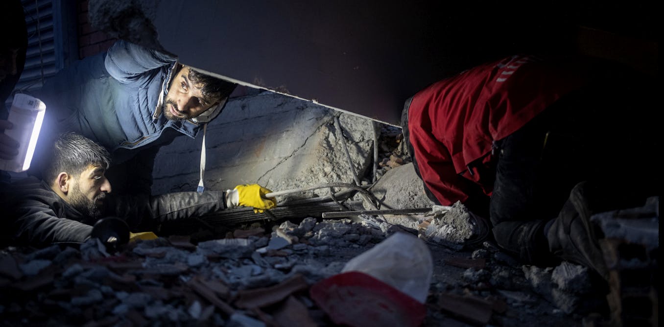 |
People search for survivors beneath the rubble in Diyarbakir, Turkey. February 6 2023.
EPA-EFE/Refik Tekin
|
The woman who gives her name as Keyser in Antakya is desperate, but there is no one to help. Through "the stench of dead bodies waft[ing] through the cold, dusty air",
her two sons, trapped below the rubble of their collapsed apartment
building could be heard crying for rescue. She tried for two days to
approach anyone with a vestige of authority to help rescue her children.
In the end she failed. There was no one available, no emergency
response leader she could make contact with, to order her sons' rescue.
A day later, neighbours reported that there were no more survivors pulled from the building's wreckage. "The general problem here is of organization, especially in the field of health",
observed Onur Naci Karahanci, a doctor working out of Turkey's
southeastern city of Adiyaman. There were not even enough body bags for
the dead, an acute shortage in the first two days following the two
earthquakes.
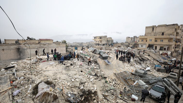 |
| Collapsed buildings in Armanāz, Syria.
EPA-EFE/Yahya Nemah |
The
trembling of the earth collapsed thousands of buildings in countless
towns and cities, leaving rubble under which were thousands of people, a
scant handful of whom were rescued. Antakya in particular, known
historically as Antioch, the capital of Hatay province. The damage
realized in Turkey was estimated by the Turksh Enterprise and Business
Confederation at $84.1 billion. Human life was destroyed to a total of
30,000 in Turkey alone.
Rescue
teams flew in from various countries, both near Turkey and Syria, and
from parts distant. Astonishing stories of survival and rescue have
surprised and encouraged rescue teams, but the total, still growing, and
standing at 36,000 dead is a grim reminder of the force and extent of
the catastrophic natural disaster. On one occasion, a father with a
child in his arms was rescued, in another a baby with its mother's hair
clutched in its fist; a newborn; a 13-year-old boy saved a week after
being buried alive
Over
150,000 survivors have been moved to shelters outside the affected
provinces, according to Turkish authorities. Turkey is now a country
that has been markedly changed, where the massive earthquakes cut a
slash through the landscape shifting roads, bending and breaking rail
lines, smashing buildings to the ground. There are now new canyons
across the East Anatolian Fault running through southern Turkey and
northern Syria.
The
window for finding survivors is fading. Rescue work moving vast
tonnages of steel and concrete to find anyone still alive is now turning
to the need to complete the work of destroying unsafe buildings
partially destroyed. The work of the moving tectonic plates; where the
fault line that slipped to cause the quakes -- the East Anatolian
between Turkeys Anatolian Plate and the Arabian Plate -- moving
northward created a double disaster.
Turkey's
geologic crust was altered in a few seconds when the plates slipped
side to side leaving rail lines bent into S-curves, roads laterally
split. Where an olive grove in Altinozu split in two leaving a
200-metre-wide rocky chasm between trees growing in neat rows, once
side-by-side.
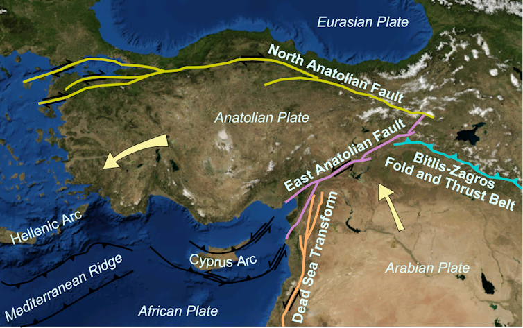 |
| Arabia is bumping into Eurasia and pushing Anatolia
westwards … or to non-earth scientists, Syria is bumping into Europe
and squeezing out Turkey.
Mikenorton/Nasa/wiki, CC BY-SA |
Labels: Death Toll, Earthquake, Natural Disasters, Search and Rescue, Survivors, Tectonic Plates, turkey-Syria
Indonesia, Earthquakes, Tsunamis, Airplane Crashes
"Mamuju is now empty, everyone went to the mountains."
"Lots of buildings collapsed and people are afraid of a tsunami."
Muhammad Ansari Iriyanto, 31, Mamuju resident
"It is certainly one of the most challenging, this [disaster] was one of our fears and now we are putting all of that planning and protocols into place."
Jan Gelfand, head, International Federation of Red Cross in Indonesia
With a population of over 260 million, Indonesia's location on the "Ring of Fire", an arc comprised of volcanoes and fault lines in the Pacific Basin, ensures its vulnerability as a frequent victim of earthquakes, volcanic eruptions and tsunamis. On Friday, the Indonesian island of Sulawesi suffered a powerful tremor as a 6.2-magnitude earthquake struck, trapping people under rubble, unleashing dozens of aftershocks. Authorities gave warning of more quakes to follow that might result in a tsunami.
Earthquakes frequently strike there with deadly consequences. In 2018 a devastating quake of the same magnitude and a tsunami that followed killed thousands in the city of Palu, in Sulawesi. In 2004 a 9.1-magnitude quake off Sumatra island triggered a tsunami on Boxing Day lashing coastal areas of Indonesia, Sri Lanka, India, Thailand and nine other nations for a death toll of over 230,000.
Fearful residents in their thousands streamed out of homes making for higher ground after the quake struck six kilometres northeast of the town of Majene, its depth 10 km. Over 300 homes and two hotels were damaged by the quake and its aftershocks. An area hospital was destroyed along with the office of a regional governor where several people were trapped under the rubble when the building was flattened.
To the present, the number of dead stands at 56 with close to a thousand people injured. Seismic activity caused three landslides, severed electricity lines downed, and damaged bridges linking to regional hubs. Heavy rain hampered rescue efforts and made conditions even worse for the homeless seeking shelter. The residents await with an agony of trepidation the appearance of a tsunami that another powerful quake could unleash.
 |
| Residents gather at a makeshift shelter in Mamuju on Saturday, a day after the quake rocked Indonesia's Sulawesi island. (Muhammad Rifki/AFP via Getty Images) |
Since the initial quake another 26 aftershocks had occurred. Friday's quake had been preceded by a quake of 5.9 magnitude the day before. People panicked, seeking refuge in the nearby hills as residents fled to higher ground on motorcycles. People desperately tried to shift debris with their hands to rescue a young girl trapped under rubble. Rescue workers made use of all available equipment in hopes of freeing survivors and locating the dead.
Restoring bridge links to ensure the delivery of tents, food and medical supplies is the highest priority of emergency workers, for the 15,000 people who have fled their homes since the quake occurred. Expectations are that distribution of aid will be complicated by the coronavirus pandemic.
 |
| Rescuers search for survivors at a collapsed building in Mamuju city on Saturday. (Hariandi Hafid/AFP via Getty Images) |
Labels: Earthquake, Indonesia, Natural Disasters
China's Environmental Misery
"This flood battle is a practical test of the leadership and command system of our army, and the army's combat readiness and ability to perform the tasks." Chinese President Xi Jinping
"There is no room for suffering [unseen by drone footage shot from afar]." "The images of floods sweeping away homes, pigs and humans drowning, corpses rotting and garbage spread all over after the floods will never be captured by drones in bird's-eye views." Zhang Feng, media critic, Beijing
 |
| Water is discharged Tuesday from the Three Gorges Dam in Hubei Province.
© Xinhua via Kyodo |
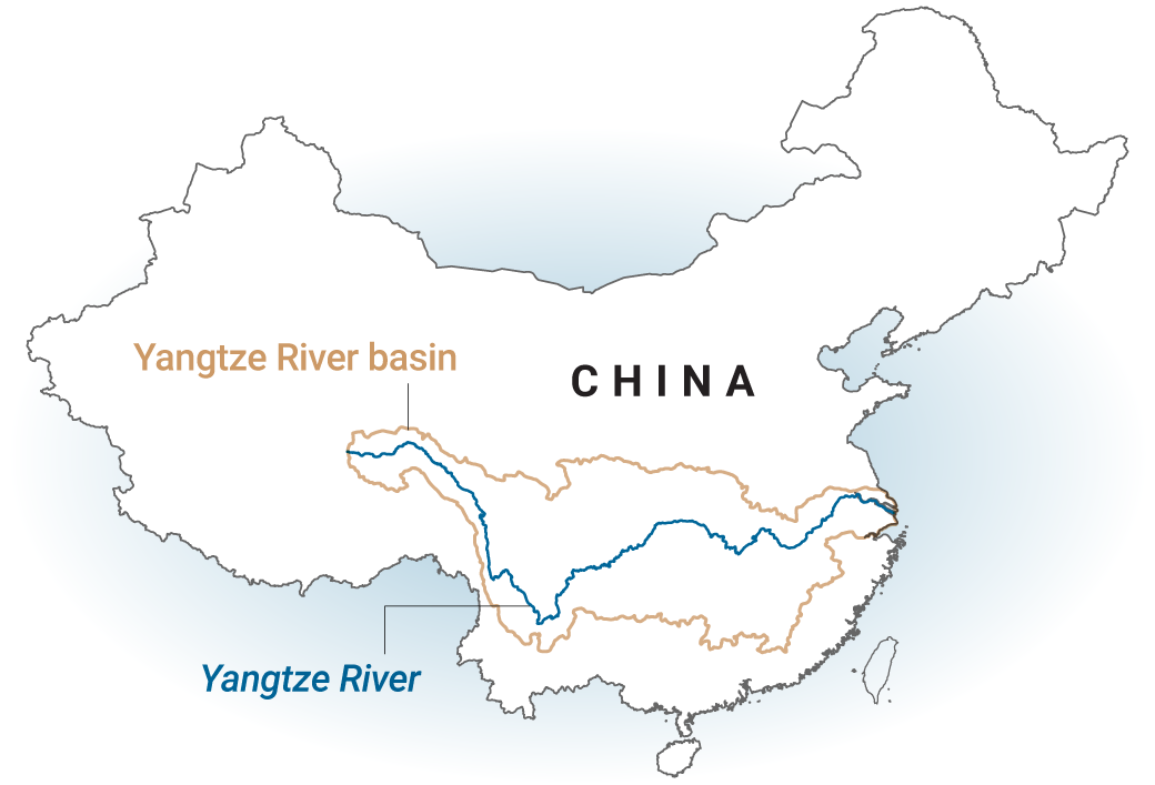
August represents the third month of large-scale flooding in China, creating damage truly catastrophic even while the country grapples with the outcome of the SARS-CoV-2 pandemic. Where the Jialing River meets the Yangtze waters have risen to the extent that the ancient village of Ciqikou was inundated by five feet of water; highways vanished, waves cresting threatened elevated rail tracks. China's central provinces reaching to the upper Yangtze has been devastated.
The area includes Chongqing, with its 30 million residents and Sichuan province in the southwest affecting up to the present, 63 million people. An area of farmland -- 15 million acres -- has been destroyed. The government has officially placed the floods on an equal level as the coronavirus pandemic in its shock value that China is suffering through. The potential of a sixth wave of flooding striking in September due to ongoing rainfall reaches into the near future.
The scale of the call-up mobilizing the People's Liberation Army to provide disaster relief emphasizes the grave crisis and urgency of the response to the catastrophe. Where the Chinese military has mobilized 1.3 million troops across 17 provinces in the evacuation of 170,000 residents and to reinforce embankments and roads. Yangtze water levels in Chongquing hit a record days ago. The flood peak at the Three Gorges Dam has seen record water levels, with dam operators on "wartime footing".
 |
| A house leans over in the floodwater, Jiangxi province. |
A hydrologist at Sichuan University, Zhang Faxing, noted that summer floods routinely occur at Sichuan. However a disaster of the scale of the current floods and the level of rainfall lasting into August is truly unusual. "We should stay on alert for further flooding in upper and middle reaches of the Yangtze until mid-September", he warned.
According to the Chinese origin myth dating back four thousand years, King Yu founded the first prehistoric dynasty when he overcame a great flood. China badly needs another King Yu, and its current president is prepared to present himself as such, to rescue his country from the clutches of a yearly natural phenomenon which this year coupled with a global pandemic that originated in China has made 2020 a very special year.
One where government officials warn increasingly extreme weather and flooding are becoming even more extreme in the grip of climate change. A joint report produced in 2015 by several Chinese ministries noted the that country was vulnerable to drought, flooding and sea level rise, given environmental change.
Not that human intervention in the natural order of China's geology hasn't had a hand in worsening the situation. Intense reclamation and development of wetland along the Yangtze River is implicated in impairing the basin's capacity to absorb floods, according to experts.
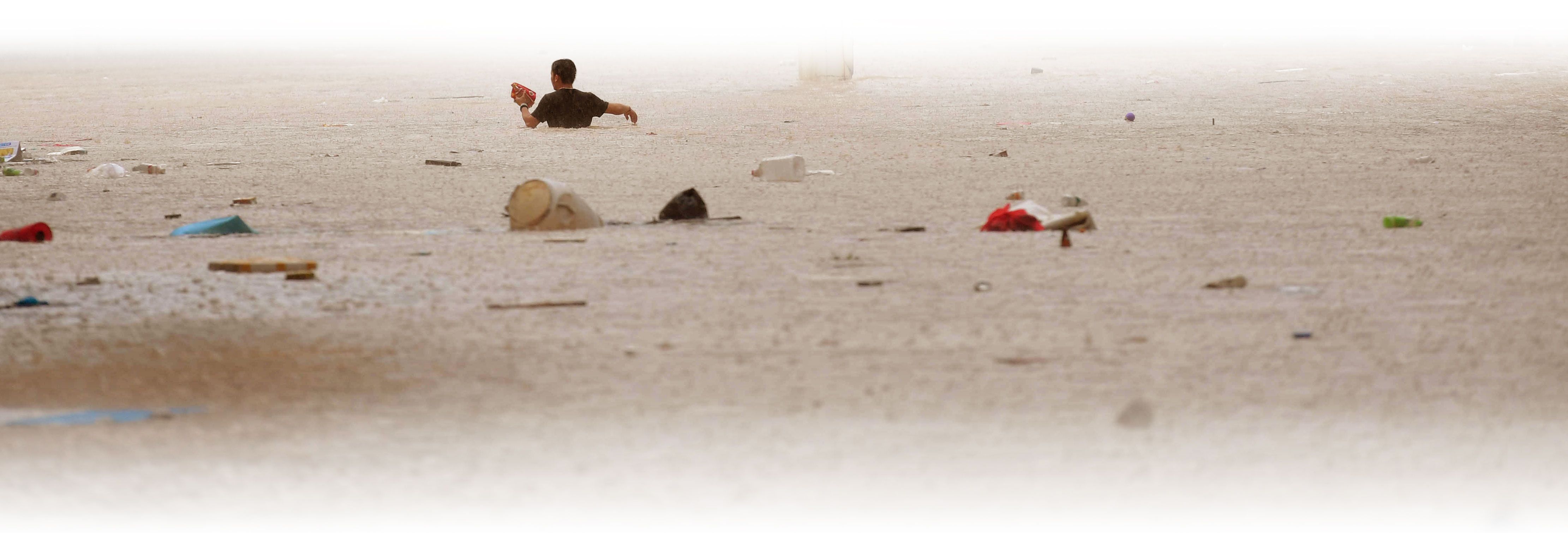 |
| Heavy rains in south China's Guangxi Zhuang Autonomous Region caused floods and blocked roads leading into villages. |
Labels: China, Flooding, Natural Disasters
Surviving a Tropical Cyclone
"This [Cyclone Fani] is not as bad [as the 1999 super cyclone]."
"Apart from these winds which may cause damage in terms of uprooting small trees in West Bangal and some big trees in Odisha and extensive damage to thatched houses and mud houses ... [and] disruption of power and telecommunication lines, it can also impact the rail and road traffic and also air traffic for some time."
Mrutyunjay Mohapatra, Meteorological Department scientist, India
"In the event of such a major calamity like this — where Odisha
was hit by close to a super-cyclone — instead of being a tragedy of
humongous proportion, we are in the process of restoring critical
infrastructure."
"That is the transformation that Odisha has had."
Naveen Patnaik, Odisha state top government official
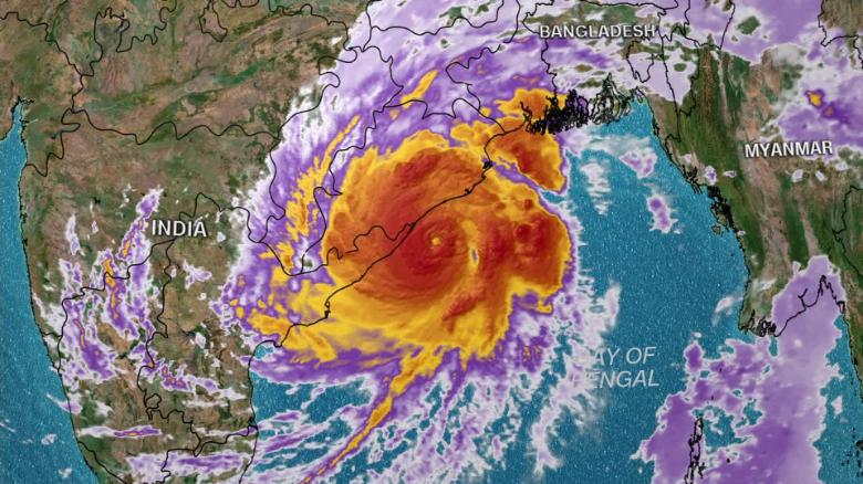
The description of the potential damage that a cyclone with lashing rain and winds gusting up to 205 km/h can impact on a geographical area sounds fearful enough in its damaging action on peoples' homes and civic infrastructure to send shivers up and down the spine of people fortunate enough to live in areas of the globe geographically distant from such tropical storm systems. The reality of the damage that the cyclone did inflict on the coastal state of Odisha was sufficiently fearful, withal.
The desert state of Rajasthan bordering Pakistan was impacted by huge dust storms, while on the Arabian Sea the coastal state of Maharashtra saw heat waves and elsewhere bordering China, heavy rains descended, reaching to the Himalayas where the rain fell in the frozen state of mountainous snowfalls. Fani represented the second-most severe of cyclones in India's meteorological measurements, equivalent to a Category 3 hurricane.
"[It is a] very, very scary feeling", Tanmay Das, 40, a resident of Bhubaneswar, a city in Odisha said, describing
"the sound of wind as if it will blow you away". Violent enough to whip palm trees like flexible rubber mops against almost-opaque rain-gusting skies. The thatched-roof houses in the area were all destroyed. Electricity was cut off. Electricity poles were down, alongside fallen trees.
 |
| A marooned elderly couple sit on a log close to their home surrounded by high waters in Khulna, Bangladesh on Saturday. (Munir uz Zaman/AFP/Getty Images) |
Rail lines were closed, the Kolkata airport was closed, and an estimated 200 trains across India saw cancellation as the storm hit in the midst of India's six-week general election, forcing cancellation of political campaign events around Kolkata as the cyclone in the Bay of Bengal hit, impacting weather across the Asian subcontinent.
As astonishing 1.2 million people were evacuated from Odisha's low-lying areas, moved to an equally amazing four thousand shelters, a plan carried out by India's National Disaster Response Force. The Indian navy, air force, army and coast guard were placed on high alert. This was a first for India, an unprecedented evacuation of immense proportions. Friday afternoon saw the cyclone downgraded t a
"very severe" storm.
 |
| Neighbours
show damage caused by Cyclone Fani in the Penthakata fishing village of
Puri, in the eastern Indian state of Orissa on Saturday. (Associated Press) |
There was a dispatch of 54 rescue and relief teams of doctors, engineers and deep-sea divers to areas along the coast prone to flooding, as far afield as Andaman and Nicobar Islands in the Bay of Bengal; the work of the National Disaster Response Force. Sri Lanka, off the eastern tip of India was expecting up to four inches of rain.
On Mount Everest, mountaineers and Sherpa guides descended to lower camps to wait out the worsening weather after a warning was issued that heavy snowfall was expected at higher elevations. Trekking agencies were required to take tourists to safety, so hundreds of climbers, guides, cooks and porters took haven from the weather raging about them, leading to poor visibility, at the Everest base camp.
 |
| A family crosses the Buriganga River by boat during rainy weather in Dhaka, Bangladesh on Saturday. (Monirul Alam/EPA-EFE) |
The 1999 "super" cyclone in the Bay of Bengal killed roughly ten thousand people, devastating large areas of Odisha. More reliable forecasts and improved disaster management coordinating saw a vastly better outcome. The 2013 Cyclone Phailin led to the deaths of fewer than fifty people, in contrast to the wind speeds of 260 to 280 km/hr in 1999 that took such a huge death toll.
This time, there were fifteen deaths, and an unknown number of injuries, considerably smaller in numbers reported, thanks to the monumental task of moving 1.2 million people to temporary haven and safety from the initial grade 5 storm that was cyclone Fani. Now, it is the turn of Bangladesh where already a dozen people are reported to have been killed by the effects of the downgraded
"severe storm".

Labels: Bangladesh, Cyclone, India, Natural Disasters, Weather